Thiessen polygon method of regional delimitation UPSC
The Thiessen polygon method is used to mark the functional region boundaries.
This method was used in the USA to identify the rainfall region. There is a unique property of the Thiessen polygon that there is only one node in each polygon.
The following three steps were used to mark the boundaries of the region.
Step-1:
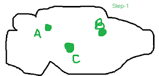
Identify the major function nodes' location over geographical areas for finding the functional region of nodes. In the below figure, A, B, and C are the functional node of geographical areas.
 |
| Step-1 |
Step -2:
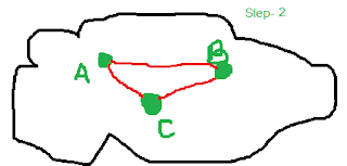
Connect all nodes with the line. In the below figure, Triangle ABC will form by connecting the functional notes of A, B, and C.
 |
| Step -2 |
Step -3:
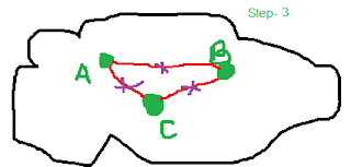
Mark the middle point of the line AB, BC, and CA.
 |
| step-3 |
Step-4:
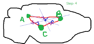
Create the longitudinal line from the middle point from each edge. The intersection of all these longitudinal lines will create one center node.
 |
| step-4 |
Step-5:
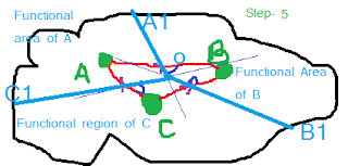
Connect the line starting from the center node ( i.e "O") to the middle note of each edge and extend it up to geographical boundaries (marking A1, B1, and C1). A polygon drawn from connecting to this longitudinal line in which only one node should be there is called Theissen polygon.
 |
| step 5 |
Finally:
- The functional region of A will be the area of A1OC1.
- The functional region of B will be the area of A1OB1.
- The functional area of C will be the area of C1OB1
Uses of Theissen polygon:
- In land-use planning
- Identifying the functional area of hospitals, Schools, Shopping malls, cities, etc.
- Rainfall pattern area identification
Try to solve the following questions.
- What is a ‘region’? Describe the ‘Thiessen’ polygon method of regional delimitation. (2016, 15 marks)
You may like also:


2 Comments
Click here for CommentsCan you please tell me, the source of this question?
ReplyHindi me chahiye
ReplyConversionConversion EmoticonEmoticon