Discuss the methods of measuring the intensity and magnitude of earthquakes. How are seismic zones demarcated?
Answer.
Earthquake means is shaking of the earth. It is caused due to the release of energy which is generally in the form of a wave that travels in all directions. Earthquake is measured by generally two ways that are magnitude and Intensity.
Magnitude:
- The magnitude of earthquake measures the energy release of from source. Measurement of magnitude is Richter Scale and the Seismometer is used to measure the magnitude of the earthquake. It is being measured 1 to 10 scale. Earthquake magnitude measuring 2 is 10 times more powerful than 1.
- An earthquake measuring Richter scale more than 7 causes destruction and Richter scale 1-2 level comes daily and does not cause any harm or generally does not feel.
- It is determined by the largest wave recorded on a seismogram.
Intensity:
- The intensity of the earthquake measures the strength of shaking generated by earthquakes. The intensity of the earthquake various from location to location.
- Intensity is measure by the Mercalli Scale from 1 to 12.
Demarcation of Seismic Zone:
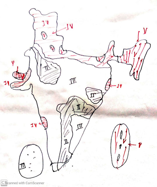
Seismic zones are demarcated based on the past data of Earthquake Intensity on Mercalli, tectonic setup in the region.
 |
| Earthquakes zone in India. |
Initially, the Bureau of Indian standard ( BIS) divided the country into five seismic zones, but after Killary Earthquake in Maharashtra in 1993, zone 1 was converted to zone II, now there are four seismic zones in India.
Zone V:
- It is the region of most intensive earthquake areas.
- A small part of Jammu Kashmir and Himachal Pradesh, the northern part of Uttarakhand, northern Bihar, North East India, Kutchh areas of Gujarat, and Andaman Nicobar island.
Zone IV:
- It is a severe intensive zone of earthquakes. It is the surrounding area of Zone V that is comprised of Jammu Kashmir, Himachal Pradesh, Delhi, Sikkim, Goa, a small part of West Bengal, and part of Gujarat.
Zone-III:
- It is a moderate intensive zone of earthquakes.
- It is comprised of Lakshadweep, Kerla, part of Tamil Nadu, Karnataka, Maharastra, part of Andra Pradesh and Telangana, Central India.
Zone-II:
- It is a low intensive zone area.
- It is comprised of Karnataka Plateau, part of Rajasthan and Odisha.
Try to solve the following questions:
- Landslide is a major problem in the Himalayan region. Discuss its causes and mitigation measures. ( 20 marks)( UPSC 2021 geography optional)
- Identify the Landslide-prone regions of India and suggest some measures to mitigate the disasters caused by these. (NCERT)
- Differentiate the causes of landslides in the Himalayan region and the Western Ghats.
- “The Himalayas are highly prone to landslides.” Discuss the causes and suggest suitable measures of mitigation.
- "Geomorphological changes are largely responsible for environmental hazards in the Himalayan region." Comment with relevant examples. (UPSC 2018, 200 words, 15 marks)
- Differentiate between the "intensity" and "magnitude" of an earthquake and explain its varying impact in different parts of India. (UPSC 2014, 200 words, 15 Marks)
You may like also:


ConversionConversion EmoticonEmoticon