Table of Contents
- Introduction of Geology
- Geological System or Geological Time Scale
- Indian Geological System
- Geological Structure of India
What is geology?
- In physical geography, the study of physical features of earth emphasized and study include earth crust, atmosphere, ocean, environment, and biological interaction.
- In human geography, we study the cultural landscape and interaction of humans and nature such as population, economy, settlement, and development theory related to geography.
- In geology, the study includes earth history, composition, rock history, process, and structure of landmasses.
The geological system or geological timescale is a sequence arrangement of rock formations of the world.
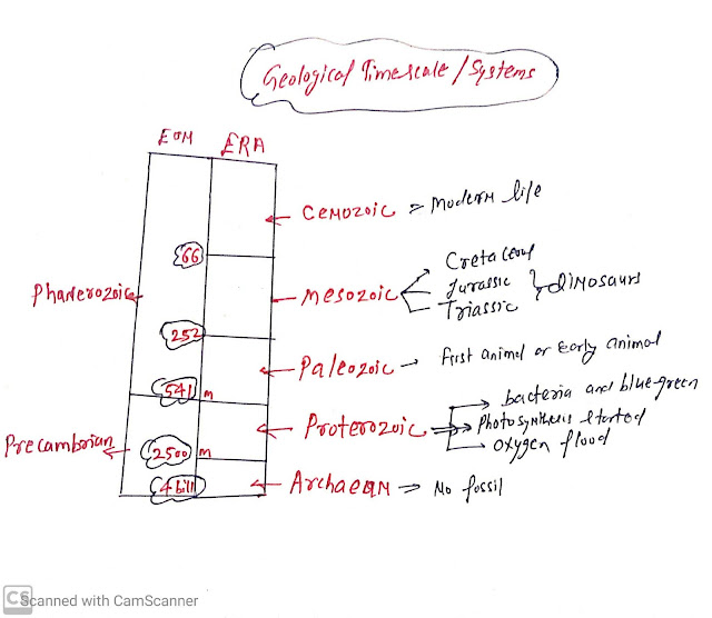
During the 18th century, the geological system is divided into primary, secondary, tertiary, quaternary. Now it has changed and the geographical time scale is now divided into :
- EONS
- Eras
- Periods
- Epochs
The following diagram will be more details about the Geological timescale:
 |
| Geological Time scale |
At present we are living,
- Phanerozoic Eons
- Cenozoic Eras
- Quaternary period
- Holocene epoch
Geological System or Geological rock system of India
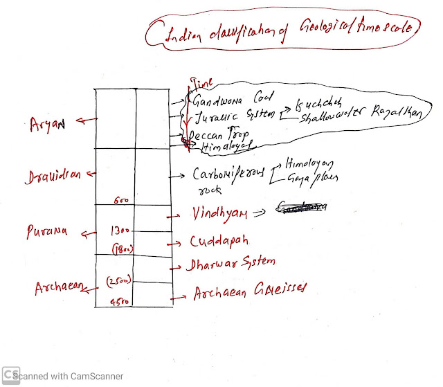
As per the geological survey of India, the country divides rocks into four major divisions:- Archaean
- Purana
- Dravidian
- Aryan rock
 |
| The geological time scale of the Indian rock system |
Archaean :
- Arches gneisses
- Dharwar system
Arches Gneisses:( 4.5 Billion to 2500 million years)
- First rock formed on earth.
- No fossils
- 2/3 rd rock of peninsula India by value comprises of archaeon Rock.
- Apart from peninsular India, the root of the Himalayan mountain is also formed by Archaean rock.
Dharwar System: ( 2500-1800 million years)
- Aravali, Chota Nagpur, Meghalaya, Dharwad region of Karnataka
- Dharwar system is made up of weathered Archaean rock.
- It also does not contain fossils but has high-grade Iron ore, manganese, copper, gold, etc.
Purana rock system;
Purana rocks formed after the erosion of the Dharwar system.
It is two types:
Purana rocks formed after the erosion of the Dharwar system.
It is two types:
- Cuddapah
- Vindhyan
Cuddapah:
- Without fossil.
- It is found in the Cuddapah district of Andhra Pradesh and southern Odisha.
- Mainly Vindhya mountain from Rajasthan to Bihar
- Vindhya system found under Deccan lava, Bundelkhand, and part of the Himalayan region.
- It has a fossil record and found the diamond, red sandstorm
- It is found in the extra peninsula region that is Himalayan and Gangetic plain
- In this rock, the beginning of coal formation is Carboniferous coal but not much is found in India.
- Has abundant fossils
- Coal reserve in this rock system
Aryan rock system:(250 million to present)
- Gondwanaland rock system
- Jurassic rock system
- Deccan trap
- Tertiary and Quarterly rock system
Gondwana rock system:
It is named after the Gond tribe of India and the rock is about 250 million years old. It is the largest source of coal in India.
Examples,
It is named after the Gond tribe of India and the rock is about 250 million years old. It is the largest source of coal in India.
Examples,
- Damodar valley in Jharkhand,
- Pench valleys in Chhattisgarh
- Godavari valley in Telangana
- Rajamahal hills in West Bengal
Jurrasic rock system:
- Shallow water deposits in Rajasthan
- Kutchh region of Gujarat
- Examples, limestone, shale
Deccan trap or Crataery rock system:
- Indian plate moving toward north it crossed over Reunion volcanic hotspot in Indian ocean and magma outpoured in the Deccan region ( Maharashtra, Karnataka, Mp)of India.
- After the collision of the Indian Plate with the Eurasian plate, some Rock developed such as:
- Kare was of Kashmir
- Satluj Gangetic Brahmaputra plain
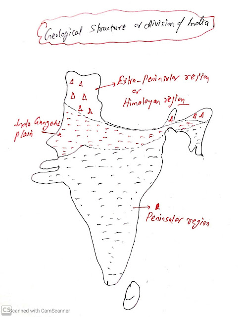
Geological Structure of India
- The oldest landmass peninsula India was part of Gondwanaland land that include India, Australia, Africa, Madagascar, South America, Antarctic.
- Due to the convection current, the Gondwana landmass breaks up into many parts about 225 million years ago.
- India and Australia got separated from Gondwanaland.
- Later It also broke out into two-part India plate moved north and Australia plate moves south.
- 80 Million years ago India is about 6400 km from its current position
- About 40 -50 million years ago, Indian plates collides with Eurasian plates.
- Due to the collision of the Indian plate into Eurasian plates. Sedimentary rocks are accumulated in the geosyncline area that is Tethys sea and Himalayan mountain created on Tethys sea.
- The northern part of peninsula subsidies under Eurasian plates and large basins are created. Over time it was gradually filled with river sediments and the great northern Indian plain developed.
Peninsular India:
- Oldest stable landmass From the Cambrian period composed of Igneous and metamorphic rocks with gently rising hills and wide valley.
- It is bordered by Kachchh, Aravali range near Delhi, parallel to gangs and Yamuna. The extension of the peninsula is found as the Meghalaya plateau.
- Some vertical movement and created block faulting.
- For example, the rift valley of Narmada, Tapi, and Mahanadi, Satpura block.


ConversionConversion EmoticonEmoticon