Question.
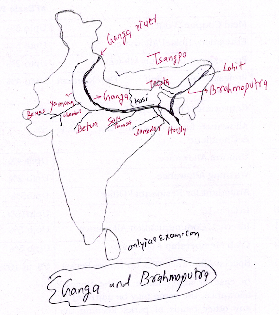
On an outline map of the Indian Sub-continent, draw the rivers Ganga and Brahmaputra from the source to the mouth. Also, show the important tributaries of both rivers.
( Chapter 8: Human-Environment Interactions The Tropical and the Subtropical Region, Class 7- Our Environment ( GEOGRAPHY), SOCIAL SCIENCE)
Answer.
The River Ganga and Brahmaputra are two of the major rivers in South Asia.
Here's a brief overview of each river, including their sources, mouths, and important tributaries:
Ganga:
Source: The Ganga originates from the Gangotri Glacier in the Indian state of Uttarakhand.
Course: It flows through northern India, passing through key cities like Haridwar, Varanasi, and Patna. It eventually empties into the Bay of Bengal through the Sundarbans Delta in Bangladesh.
Important Tributaries: Some significant tributaries of the Ganga include the Yamuna, Gandak, Kosi, and Son rivers.
Brahmaputra:
Source: The Brahmaputra begins in Tibet as the Yarlung Tsangpo River. It enters India in the state of Arunachal Pradesh.
Course: After entering India, it flows through the northeastern states of Assam and West Bengal. In Bangladesh, it's known as the Jamuna River and later joins the Ganga before emptying into the Bay of Bengal.
Important Tributaries: Major tributaries of the Brahmaputra include the Subansiri, Manas, and Teesta rivers.
You may like also:

ConversionConversion EmoticonEmoticon